
 Latest images

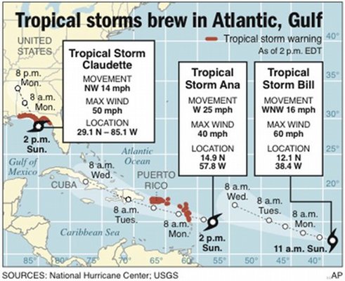
PENSACOLA BEACH, Fla. — Brewing in the Gulf of Mexico, Tropical Storm Claudette threatened to bring heavy rain to the Florida Panhandle later Sunday, likely becoming the first tropical storm to strike the U.S. mainland this year.
Claudette had winds of at least 50 mph, but was not expected to cause significant flooding or wind damage. Lurking more ominously in the Atlantic were tropical storms Ana and Bill, which was quickly turning into a powerful storm over warm waters in the open Atlantic.
At Pensacola Beach, surfers under gray skies enjoyed the waves and tourists mingled on the beach, despite a tropical storm warning covering most of the Panhandle, from the Alabama state line to the Suwanee River more than 300 miles to the east.
Miguel Gonzalez, on vacation from North Carolina, was unconcerned about the storm as he readied his children for day on Pensacola Beach. But he said his family would head in if the rain started.
"We will just stay out there for an hour or so, take a few pictures and then leave," he said.
Rainfall of 3 to 5 inches was expected, with isolated areas getting up to 10 inches, forecasters said.
"We may see some heavy rains as a result, but we don't expect any high winds or coastal flooding," said John Dosh, manager of Emergency Management. "This event is a good example of how quickly a tropical storm can develop. We won't always have a lot of warning. This is why citizens need to be prepared throughout hurricane season."
Pensacola Beach is still recovering from Hurricane Ivan, which devastated the western Florida Panhandle and parts of Alabama in 2004.
At 2 p.m. EDT, Claudette was about 40 miles south of Apalachicola and moving northwest near 14 mph. Its center was expected to reach the northern Gulf Coast by Sunday evening.
Meanwhile, Tropical Storm Ana had top sustained winds of 40 mph and was expected to make landfall at the Leeward Islands early Monday. Watches were posted for Puerto Rico, the U.S. and British Virgin Islands, Antigua, St. Maarten and several other islands in the area. Ana was forecast to bring 2 to 4 inches of rain.
Tropical Storm Bill, however, was intensifying far from land in the open Atlantic, and could become a hurricane Monday.
In the Pacific, Hurricane Guillermo had winds of 100 mph, but was expected to lose steam in the next day or two. Guillermo was moving west at 15 mph, about 1,150 miles east of Hilo, Hawaii, and didn't threaten any land.
Despite the three tropical storms and a hurricane, a warmer weather pattern called El Nino over the Pacific Ocean is generally expected to damper the formation of tropical storms in the Caribbean and Atlantic this year, said Brian Daly, a meteorologist with the national weather service in Mobile, Ala.
"It's pretty frequent that an El Nino year would be somewhat delayed with fewer storms," Daly said.
Forecasters revised their Atlantic hurricane season predictions after the first two months of the season passed without any named storms developing.
___
Associated Press writer Desiree Hunter in Atlanta contributed to this report.
Source: Comcast.net
No Comment.